


These are personal notes, written in November 2018, by Roger Kayes, head of the Perranzabuloe NDP Housing Group on the question.
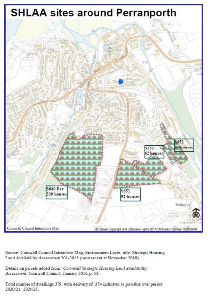
Following the flurry of interest in the Perranporth map (screen shot of the CC Perranporth SHLAA map below) of Strategic Housing Land Use Availability Assessment (SHLAA) sites referred to at the Perranporth meeting of the NDP group on the 21st of November 2018, it might be helpful to give any concerned residents further information to clarify what a SHLAA site is, and is not. There are no SHLAA sites, to my knowledge, in other areas of Perranzabuloe that have not already gone on to receive planning permission.
 Cornwall Council’s information on this is very helpful:
“The National Planning Policy Framework (NPPF) requires all Local Authorities to carry out Strategic Housing Land Use Availability Assessment as part of the evidence base for the Local Plan.
Cornwall Council has prepared and regularly updates SHLAA to support the Cornwall Local Plan. The SHLAA is a technical document that identifies sites across Cornwall which shows initial potential for providing 10 or more new homes. The SHLAA automatically excludes sites which are:
- Not connected to a settlement within the Settlement Hierarchy.
- Within a designated Special Area of Conservation, Special Protection Area and/or Site of Special Scientific Interest.
- Within Flood Zone 3b.
Sites are largely included in the SHLAA on the basis of a broad-brush desktop assessment which means that their inclusion in the SHLAA does not imply that they would necessarily be granted planning permission or are suitable for allocation for residential use. Nevertheless, with the vast majority of the sites having been put forward by the landowners, it is a good guide to what sites are available. The SHLAA also provides an indication of how many homes could be delivered and when, based on input from the landowners, density calculations and typical build-out rates.”
From: Cornwall Council Neighbourhood Planning Guidance Note: Housing Land Availability Assessment
Key points are stated very clearly in another document available online (cornwall-shlaa-report-january-2016 – the most recent version as far as I know):
“Box 1: Status of the Cornwall SHLAA Report and Identified Sites
The Cornwall SHLAA is not a planning decision making document. It makes broad assumptions in terms of site suitability in order to bring forward a wide range of sites for consideration of housing potential. Sites that are identified in the Cornwall SHLAA would be required to be further tested by the planning application or allocation processes including consideration of sustainability and planning criteria, development plan policies and consultation before they could be deemed suitable in planning terms.
In summary:
- The SHLAA is not development plan policy;
- The SHLAA does not indicate that sites will be granted planning permission;
- The SHLAA does not preclude sites from being developed for other suitable uses; and
- The SHLAA is an important evidence base technical document but is not a planning decision making document.
The SHLAA does not preclude other sites which have not been submitted or assessed during this process from coming forward for housing.”
The web page on Cornwall Council’s site gives further information and links, including where to find the original version of the map presented here: https://www.cornwall.gov.uk/environment-and-planning/planning/planning-policy/adopted-plans/evidence-base/strategic-housing-land-availability-assessment/
Note dated November 23rd 2018